Flexible Adaptation
The eMD10 supports various construction techniques such as point tamping, full tamping, etc. It takes into account the design of tamping point and construction without a tamping point. Adaptable to different brands and types of rammers without system limitation. The eMD10 supports global coordinate library, multi-project and multi-site management, and network differential.
Data Tracing and Platform Communication
The eMD10 automatically collects and flows the whole process data, electronically archiving it for convenient data query, statistical analysis, and decision-making support. Construction process data visualization displays in real-time, allowing playback of the construction process. The eMD10 system communicates with the digital construction management platform in two directions. It can remotely send out construction tasks and display construction work data visually.
Operation Convenience
The eMD10 supports clients to create design files locally, eliminating the need for complex design processing conversion on PC software. The system enables fast construction. It is not affected by the environment and allows 24-hour construction. The eMD10 automatically identifies ramming points and records key data such as the number of ramming strokes, ramming distance, and ramming sedimentation.
Security
Stakeless construction reduces the need for surveyors to sample the construction datum line, enhancing the safety of the construction site. The electronic fence allows the setup of danger avoidance zones, improving construction safety.
Quality Monitoring
The eMD10 allows remote monitoring of the construction process, quality, and progress. It enables timely detection of deviations and provides early warning for corrective treatment. Real-time recording and transmission of key parameters of the construction process to ensure the quality of construction.
Wide Application
The eMD10 is widely used in foundation reinforcement projects for residential buildings, highways, airports, railroads, squares, stadiums, industrial plants, ports, wharves, warehouses, petrochemical plants, and nuclear power plants.
|
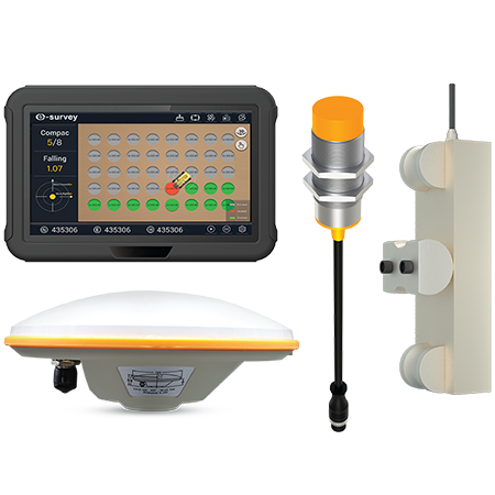
Product |
eMD10 | |||
|
MA-4 GNSS Antenna | ||||
|
Signal received |
GPS: L1/L2/L5 GLONASS: L1/L2/L3 BEIDOU: B1I/B2I/B3I/B1C/B2a/B2b Galileo: E1/E5a/E5b/E6 QZSS: L1/L2/L3/E6 IRNSS: L5 L-band | |||
|
Nominal impedance |
50Ω | |||
|
Polarization |
RHCP | |||
|
Axial ratio |
≤ 3dB | |||
|
Horizontal Coverage Angle |
360° | |||
|
LNA Gain |
L1 band:38±2dB; L12 band:38±2dB | |||
|
Operation Current |
≤ 45mA | |||
|
Dimension |
Φ 150mm × 62.2mm | |||
|
Connector |
TNC female | |||
|
Differential Transmission Delay |
≤ 5ns | |||
|
Temperature |
Working temperature: -45 ~ +70℃ Storage temperature: -55 ~ +70℃ | |||
|
Waterproof |
IP69K | |||
|
Weight |
≤ 450g | |||
|
Mounting |
BSW5/8"-11 screw, depth12-14 mm | |||
|
Operating Voltage |
+3.3 ~ +18V DC | |||
|
Humidity |
95% Non-condensing | |||
|
MDP-1 Display | ||||
|
GPU |
8 Cores, Supports OpenGLES 3.1 | |||
|
OS |
Android 9.0 | |||
|
RAM |
2GB | |||
|
ROM |
16GB | |||
|
Screen size |
10.1 inch TFT LCD | |||
|
Resolution |
1024 x 600 | |||
|
Brightness |
750 cd/m | |||
|
Touch panel |
Capacitive (Supports five-finger touch) | |||
|
Input voltage |
9 ~ 36V dc | |||
|
Dimension |
281mm x 181mm x 42mm | |||
|
Weight |
1.5kg | |||
|
Operating temperature |
-20℃ ~ +70℃ | |||
|
Storage temperature |
-40℃ ~ +85℃ | |||
|
Water/dust proof |
IP65 | |||
|
Channels |
432 | |||
|
Satellites Tracking |
GPS: L1, L2 BDS: B1I, B2I GLONASS: G1, G2 GALILEO: E1, E5b QZSS: L1, L2 | |||
|
Cold Start |
< 25 seconds | |||
|
Recapture Time |
< 1 second | |||
|
Positioning Accuracy |
RTK: H: 8mm + 1ppm; V: 15mm + 1ppm Single: H: 1.5m; V: 2.5m | |||
|
Observation Accuracy (RMS) |
BDS | GPS | GLONASS | GALILEO |
|
B1/L1 C/A/E1 Code |
10 cm | 10 cm | 10 cm | 10 cm |
|
B1/L1 /E1 Carrier Phase |
1 mm | 1 mm | 1 mm | 1 mm |
|
B2/L2P(Y)/L2C/E5b Code |
10 cm | 10 cm | 10 cm | 10 cm |
|
B2/L2P(Y)/L2C/E5b Carrier Phase |
1 mm | 1 mm | 1 mm | 1 mmm |
|
Initialization |
< 5 seconds (typical) | |||
|
Initialization Reliability |
> 99.9% | |||
|
Differential Format |
RTCM v3.0/3.2 | |||
|
Data Format |
NMEA0183 | |||
|
Observation Data Update Rate |
20 Hz | |||
|
Positioning Data Update Rate |
20 Hz | |||
|
Orientation Precision |
0.2°/1m | |||
|
Timing Accuracy (1PPS) |
20 ns | |||
|
Speed Precision |
0.03 m/s | |||
|
Wi-Fi |
2.4GHz/5.8GHz Wi-Fi, IEEE 802.11 a/b/g/n/ac | |||
|
Wi-Fi Hotspot Sharing |
Support | |||
|
Bluetooth |
Support | |||
|
SIM Card |
4G/LTE (Optional dual SIM card) | |||
|
GNSS |
GPS/BDS/GLONASS | |||
|
Voice |
Built-in microphone, built-in speaker | |||
|
USB |
USB 2.0 x 1 | |||
|
CAN |
CAN BUS x 1 | |||
|
COM |
RS232 x 2, RS485 x 1 | |||
|
Ethernet |
Support | |||
|
Vibration Standards (at work) |
MIL-STD-810 | |||
|
Humidity |
95% Non-condensing | |||
|
DS-2 Sensor | ||||
|
Operating Frequency |
13.56 MHz | |||
|
Support Protocol |
ISO 15693 standard | |||
|
Read/write Distance |
0 ~ 25mm | |||
|
Communication Interface |
RS485 | |||
|
Communication Rate |
9600 ~ 115200 bit/s | |||
|
Power Supply Voltage |
24V DC(9 ~ 30V) | |||
|
Maximum Current |
< 0.07A@24V DC | |||
|
Indicator |
2 LED indicators | |||
|
Dimension |
φ 30mm x 87.5mm | |||
|
Weight |
100g | |||
|
Fixing Method |
Thread screwing or nut fixing | |||
|
Shell Material |
Nickel-plated brass | |||
|
Shell Color |
Silver | |||
|
Working Temperature |
-40℃ ~ +85℃ | |||
|
Working Humidity |
≤ 65mA @ 10V DC, ≤ 60mA @ 24V DC | |||
|
IP Rating |
IP67 | |||

 No.8 Kechuang 12 Street, Economy & Technology Zone, Beijing, China.
 overseas@unistrong.com
 +86 400-999-8088 (Press 3)


