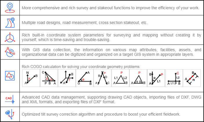
Powerful Functions
Enjoy the powerful functions, including tilt survey, CAD, line stakeout, road stakeout, GIS data collection, COGO calculation, QR code scanning, FTP transmission, etc.
Abundant Formats for Importing and Exporting
Directly import and export files with frequently used formats and customized formats.
Easy-to-use UI
Freely choose the desired display style, including list, grid, and customized style, and enjoy easy operations with graphic interaction, including COGO calculation, QR code scanning, FTP transmission, etc.
Advanced Display of Base Maps
Supports the import of different formats of base maps including, but not limited to AutoCAD formats (DXF, DWG), SHP and Land XML, which provides a more user-friendly experience during fieldwork.
Compatible with Any Android Devices
Use it on all Android devices (Android 7.0 and above), including eSurvey handhelds, Android phones, tablets, and other third-party Android devices.
Powerful CAD Function
The powerful CAD function built in Surpad4.2 supports the import, export, creation, and editing of CAD graphics either on or outside of the field.
Key Functions
|
Software |
SurPad4.2 |
|
Basic Information | |
|
Platform |
Android |
|
Update |
Online update |
|
Activation |
Online activation |
|
Communication | |
|
Bluetooth |
Support |
|
Wi-Fi |
Support |
|
Serial port |
Support |
|
Simulation |
Support customized coordinate |
|
Map Function | |
|
Online |
· Google street map · Google satellite map · Open street map |
|
Offline |
SHP, DXF, DWG, XML |
|
Coordinate System | |
|
Predefined |
Large number of coordinate systems |
|
Localization |
Four parameters, seven parameters |
|
Geoid files |
GGF, SGF, UGF, customized EDS |
|
Grid files |
GSB, customized GDS |
|
Sharing function |
Share with QR code or save locally |
|
RTCM1021~1027 |
Support |
|
Grid to ground |
Support |
|
Import & Export | |
|
Export |
CSV, DAT, DXF, KML, GPX, HTML… |
|
Import |
CSV, DAT, TXT, DXF, KML… |
|
Survey Mode | |
|
Point type |
· Topo point · Control point · Quick point · Auto point by time/distance · Corner point · Tilt point · Stop and go |
|
CAD entity |
Line, polyline, rectangle, polygon, circle, arc, spline |
|
GIS Function |
Support |
|
CAD Function | |
|
CAD format |
DXF, DWG, XML |
|
CAD drawing |
Support |
|
CAD calculation |
Angle, distance and area |
|
COGO | |
|
COGO function |
Coordinate inverse calculation Point line calculation Vector Two lines angle Intersection calculation Resection Forward intersection Coordinate positive calculation Offset point calculation Equal point calculation |
|
Stakeout | |
|
Stakeout target |
Point, line, road, cross section |
|
Stakeout reference |
North or forward direction |
|
Voice |
Support voice prompt |
|
Language | |
|
Software language |
English Simplified Chinese Traditional Chinese Portuguese Korean Polish Spanish Turkish Russian Italian Japanese Magyar Swedish Serbian Greek French Bulgarian Slovak Czech Finnish German Lithuanian Vietnamese Norwegian |

 Building B, No.4 Yongjia North Road, Haidian District, Beijing, China
 overseas@unistrong.com
 +86 400-999-8088 (Press 3)


