"Atlas" is an innovative, industry-leading GNSS-based global L-band correction service released by UniStrong in June of 2015. It enables the GNSS users to get enhanced high- precision data from anywhere in the world without setting up a base station and enjoy the service of sub-meter, decimeter and centimeter-level accuracy positioning services.

"Atlas" broadcasts differential data to the world through L-band geosynchronous orbit communication satellites, enabling more areas not covered by ground-based augmentation network signals such as oceans, deserts, and mountainous areas to achieve high-precision positioning services. Tests have shown that "Atlas" is fully ahead of similar international service systems in key indexs such as positioning accuracy, relative accuracy and convergence time. "Atlas" has all independent intellectual property rights, breaking the technological monopoly of international enterprises and ensuring the security and autonomy of national geospatial information, and enhancing the international competitiveness China's satellite navigation industry on accuracy, availability and integrity. It has broad application prospects in the fields of national economy and people's livelihood such as precision agriculture, disaster monitoring, smart grid, finance and medical treatment, mobile communications, construction engineering, aviation navigation, marine, city management, resource and environmental management and agricultural and forestry applications.

System Characteristics
- Satellite-based wide-area high-precision augmentation system covering global area
- Providing sub-meter, decimeter and centimeter-level accuracy positioning services
- Users can get augmented high-precision data from anywhere in the world without setting up a base station
- Cover areas of oceans, deserts, mountains, etc where the ground-based augmented signal cannot be served.
- Fully ownership of the independent intellectual property rights to insure information security
- Broadcasting differential data through the L-band geostationary orbit communication satellites or network NTRIP
- Offering a variety of large-scale GNSS receiver and board products to support Atlas
- Providing Atlas positioning database, third-party GNSS receiver can obtain service after integration
- Through Atlas receiver relay function, third-party GNSS equipment services are available immediately
Industry Leading Capabilities
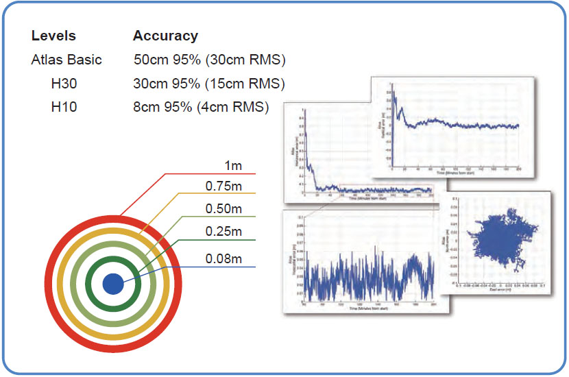
Positioning accuracy: "Atlas" provides positioning accuracies to 4 cm (RMS) in certain applications.
aRTK: With innovative tracing technology, aRTK provides positioning sustainability in the absence of correction signals.
Fast re-acquisition: Break-through the technical barrier of slow differential re-initialization. After the signal is out of lock, the initialization can be completed within 1 minute.
Convergence time: 10-30 minutes.
Applications
Surveying/Precision Agriculture/Marine/Machine Control/GIS & mapping/Auto-Steering.


 No.8 Kechuang 12 Street, Economy & Technology Zone, Beijing, China.
 overseas@unistrong.com
 +86(10)5827 5505


