 Posted by UniStrong
 2022-5-31
 6555
6555
With the rapid development of the satellite navigation industry, GNSS high-precision technology has been widely used in many industries, among which deformation monitoring is one of the most typical applications.
The application of GNSS high-precision technology in the field of deformation monitoring mainly uses high-precision positioning technology to carry out millimeter-level all-weather monitoring of slopes, dams, mines and large buildings in terms of displacement and settlement on a continuous and automatic basis, delivering early warning and forecast of abnormal situation quickly. Compared with traditional deformation monitoring approaches, the deformation monitoring solution based on GNSS high-precision positioning technology breaks through the limitations of traditional monitoring such as high cost, data lag, and monitoring vacuum period with real-time dynamic monitoring and other advantages that can more efficiently reduce and prevent the occurrence of accidents such as landslides, dam failures, tailings slope instability, and inclination of high-rise buildings.
As a leading enterprise in the field of satellite navigation applications, Beijing UniStrong Science & Technology Co., Ltd. ("UniStrong") has independently developed a series of GNSS professional monitoring receivers and automatic monitoring solutions that have been widely used in the fields of land disasters, water conservancy, mining, infrastructure and other fields in recent years.
Geological Disaster Monitoring and Early Warning Project in Guangxi Province
In the 2021 Guangxi geological disaster monitoring and early warning project, UniStrong self-developed universal GNSS monitoring receiver MIS20 delivers a multi-source integrated automatic monitoring solution with the integration of diversified sensor, Internet of Things, cloud computing and other technologies. The project embeds the GNSS monitoring and solution algorithm into the GNSS receiver, performs the front-end solution through the receiver, and directly connects the solution results to the upper-level supervision platform according to the requirements of the communication protocol, effectively improving and guaranteeing the authenticity of data through the distributed edge computing technology and supporting the geological disaster monitoring, early warning, decision-making and command before the event, auxiliary research and judgment during the event, and post-event rescue and emergency response.
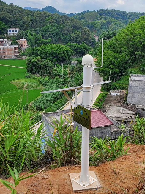
The project has installed more than 1,200 sets of monitoring equipment on nearly 200 hidden danger points, effectively improving the comprehensive capabilities of geological disasters prevention and control at a local grassroots level, and building a scientific and technological barrier for the safety of people's lives and property.
A large-scale water conservancy monitoring project in Guangxi Province
As one of the key national livelihood programs, water conservancy projects have always been the focus of attention. How to take effective measures to monitor and maintain the safety of water conservancy dams is of great significance. In 2021, the automation safety monitoring project of a large-scale water conservancy in Guangxi completed by UniStrong provides new insights for the safety monitoring of water conservancy projects.

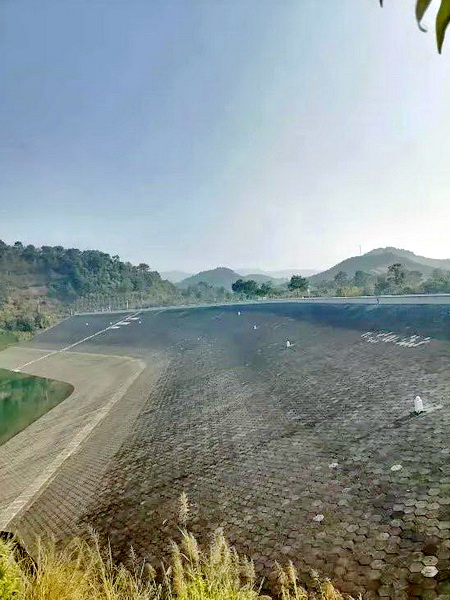
The project uses multiple sets of MIS20 receivers and GeoMS monitoring and solution management software to realize front-end networking in the intranet environment and form an automated monitoring system based on GNSS technology, combined with front-end WANET and distributed front-end solution technology, and to achieve automatic collection of horizontal displacement and vertical displacement monitoring data, automatic front-end processing, and real-time monitoring, analysis and early warning of data between the platforms. The project not only provides long-term technical support for the automatic safety monitoring of the water conservancy project, but also provides an important reference for the project to carry out various activities such as passage of ships, opening gates, releasing water, and technical support as well for the safety of life and property of tens of thousands of people downstream.
It is worth mentioning that due to the high degree of confidentiality of the water conservancy project, in order to ensure the security and accuracy of monitoring data, all equipment and servers are operated in a local area network environment, and the relevant software and hardware have been re-developed according to customer requirements, which fully proves the closed-loop operation ability of MIS20 in the environment without public network.
Slope monitoring project along a national highway in Songpan County, Sichuan Province
Songpan County is located in a mountainous area in Sichuan Province. There is a local highway used as the main traffic artery where landslides occur from time to time, which poses a huge threat to the safety of pedestrians and vehicles, and also affects the development of local tourism.
In the pilot project for the local special terrain, UniStrong adopted the universal GNSS monitoring receiver MIS20, combined with computer technology, communication technology, sensor technology, etc. to achieve real-time monitoring of slope displacement, cracks, soil water content and precipitation with timely and accurate release of early warning information.


The system breaks through the limitations of time and harsh environment and climatic conditions with an all-weather collection of monitoring data on an automatic basis. At present, some equipment has accurately captured the changing trend of landslide displacement, timely and accurately issued early warnings, effectively avoiding casualties and property losses and guaranteeing the safe passage of the road.
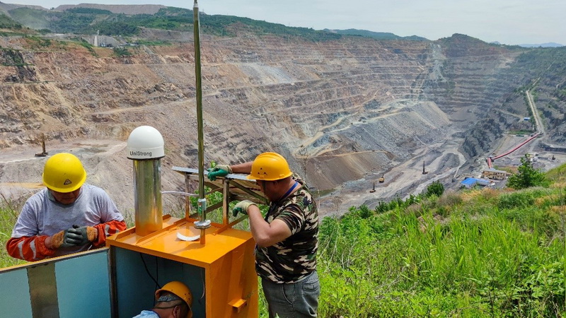
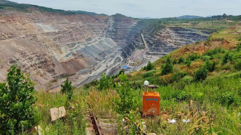
Safety monitoring project of a large open-pit mine in Northeast China
In 2021, in the safety monitoring project of a large-scale open-pit mine in Northeast China, UniStrong developed an automated safety monitoring solutions for the complex and risky on-site environment in the mining area. Based on GNSS positioning technology, the system can realize real-time collection, transmission and analysis of important operation data of key parts of the mine slope, monitor the instability changes of the mine slope, and issue a warning in the first place. The project not only provides a strong security guarantee for the safe production of the mine, but also provides a more scientific technical means and data basis for the later management of the mine.

 No.8 Kechuang 12 Street, Economy & Technology Zone, Beijing, China.
 overseas@unistrong.com
 +86 400-999-8088 (Press 3)


